|
|
 |
NEW! APRS over VARA instead of AX.25 PacketPrecision Mapping 9.0 for UIviewNotes on HF APRS OperationMagnetic Loop Antenna for 30 Meter HF APRSMap Capture Tool for APRS MapsSolving Serial Port GPS "Fake Mouse" ProblemsMapPoint/Streets/Autoroute InformationNWS Shapefile Info and Download LinksWorldwide APRS Digipeater MapsJavAPRS Filter Port GuideKenwood TH-D72 APRS HandheldLatest Updated APRS Symbols for UIview, UIpoint and APRSplus |
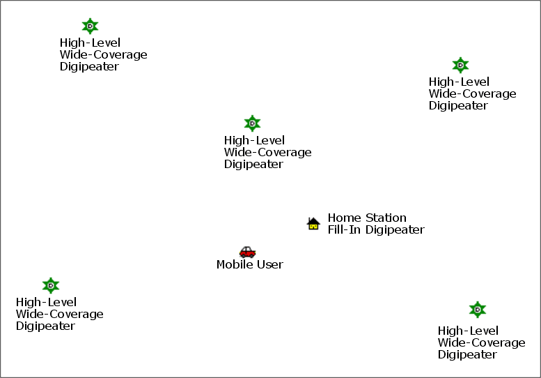
| A combination of GPS, amateur
radio and the Internet, APRS produces real-time position
reports and map displays of the location of home stations, moving vehicles, weather, and
more. GPS-generated position reports are transmitted every few minutes by packet radio from mobile units on the 2-meter (VHF), 70-cm (UHF)or 30-meter (HF) ham bands. These reports are received and relayed over great distances by fixed stations that volunteer to act as "digipeaters" (digital repeaters). Ultimately, fixed stations with full-time Internet connections ( "Igates" -- Internet Gateways) then take this data off-the-air and send it to a sytem of 40-odd specialized interconnected Internet servers known as the APRS Internet System a.k.a. "APRS-IS". Anyone can then view the position of individual stations, displayed on maps, by either:
Enter one of the addresses below into any web browser. |
|
http://map.findu.com/callsign
http://aprs.fi/callsign
|
|
|
|
| Current Recommended APRS Path Settings | |
| N1VG Balloon Launch Tracked By APRS | |
| K6RPT Balloon Launch Tracked By APRS | |
| Updated APRS Symbols for UI-View and APRSplus | |
| Sound
Effects in audio .WAV file format for
use with UI-View, APRSplus or other similar programs. |
|
| KPC3+ Initialization File for APRS Digipeater Operation. This is a modified version of the KPC3+ setting file by Jeff Brenton KA9VNV posted on his dididahdahdidit.com website. His was a capture of what comes OUT of a KPC3+ when you issue the DISP command to list it's current settings. Mine is a txt file you can edit to suit and then upload directly into a KPC3+ using the "Send Text File" function of a terminal program such as Windows Hyperterm. (It took me several hours of experimentation to discover the syntax for typing some of the commands into the TNC are different from the way they list when you display them!) [Right-click this link to download and save as a local file; normal left-click will open it in your web browser.] | |
| The Byonics TinyTrak encoder is the
cheapest way to equip a 2-meter voice radio to transmit APRS position reports. It is
essentially a transmit-only modem that connects between the serial data output of a GPS
unit and the mic input of a transceiver. There has been considerable confusion about
how to connect the TinyTrak's single serial port to both a computer (to configure it) and
then to a GPS receiver (to actually use it). This schematic TT_GPS_Switch.pdf (16K Acrobat PDF file) shows how to configure a TinyTrak (or the commercial TigerTrak) to accommodate both modes with a double-pole double-throw switch. When the switch is in the "Normal" mode, the GPS is fed through to the PC, so that a GPS mapping program on the computer can use the GPS at the same time as the TinyTrak. Right-click the link to download and save as a
local file onto your local drive for printing off-line. A normal left-click may open
this file in your browser if Acrobat is installed on your computer. |
|
| NEW! Packaging Idea for Byonics TinyTrak A very flexible approach to housing the TinyTrak bare board and providing power for an associated GPS. | |
| Jump to APRS-related links on my Useful Links page. | |
A copy of
the old WB4APR
(SK) APRS Website is located on this website. This is a snapshot of
the "official" APRS website as it existed on the U.S. Naval Academy server,
just before WB4APR moved to the current
http://www.aprs.org domain in July 2008.
This IS NOT a current site -- It is a historic record.Go To Historic WB4APR APRS Site Mirror |
|
 |
Mobile GPS Antenna Farm! I had all these GPS antennas and receivers on the roof of my car to test with various APRS and mapping programs. |
| NaviTra (Navigation Transceiver) is a Japanese system similar to APRS. The fore-runners of the Kenwood TM-D700 and TH-D7 transceivers were originally built for this system. Here are some screen shots from Japanese web sites about the NaviTra system. These screens are GIF graphic screen captures of pages originally rendered as text on a browser equipped with a Japanese-capable UniCode font. Since they are graphics, they will display properly on any system in any language. | |
 |
Japanese ham's homepage showing a picture of the "NaviTra" transceiver; it's clearly the same package as the Kenwood TMD-700. |
 |
Page in Japanese showing the data format for the NaviTra transmission; again very similar to an APRS beacon except for the provision for double-byte-coded characters to allow a comment field in Japanese characters. I pasted in a rendering of the same string in vanilla U.S. ASCII showing what happens when it is displayed on a computer without a Japanese character set. |
 |
Although most of this page is in Japanese, the comments in the descriptions of each field of the NaviTra transmission are in Latin characters, and make the structure of the NaviTra message clear. |
|
|
The icons used on NaviTra maps. They look extremely similar to the icons used by APRS. |
 |
Screen shot of live map generated by NaviTra web server. Looks an awful lot like JavAPRS or the DOS version of APRS. |
 |
The NaviTra system makes use of a Japanese GPS-driven moving-map system called "Pro-Atlas" that looks extremely similar to Delorme Street Atlas. This screen shot shows the same kind of bread-crumb trail and current-location/direction marker as Street Atlas' GPS presentation. |
 |
This screen shot makes it unmistakable that Pro-Atlas is a Windows program, even though it is in Japanese. |