(Courtesy of US National Oceanic & Atmospheric Administration
at https://services.swpc.noaa.gov/images/swx-overview-large.gif
| WA8LMF Home Page | Main Ham Radio Page | Updated 12 Dec 2023 |
These mapping displays are generated by multiple instances of UI-View32 and it's companion UI-Webserver program running on one computer.Details below on this page. |
|
Typically used for balloon launches, hamfests, etc. When not showing anything specific, this page shows the APRS Internet System (APRS-IS) feed for Michigan and surrounding areas, combined with off-air receive from my location in Haslett, MI. |
Expanded views of the northwestern Lower Peninsula of Michigan & Traverse City area from the APRS-IS feed. These are large high-resolution map images - larger than most browser windows. Scroll around to see all parts of the maps.
|
NOTE 1: This webserver is using TCP/IP ports14439, 14441, 14443, 14445 & 14447 rather than the customary port 80 for http . As a result, you may not be able to access it from some corporate or government Internet connections that severely firewall or otherwise restrict access to uncommon port numbers.
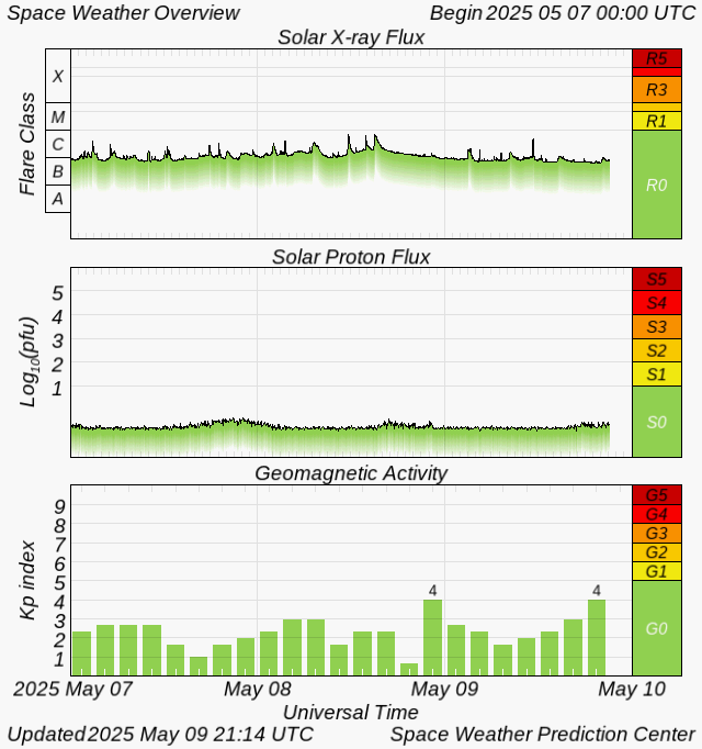
NOTE 2: Radio propagation (i.e. reception) on 30 and 60 meters HF is highly sensitive to the level of solar activity. When the solar X-ray flux plotted on the graph below has a baseline above the first major division, or spikes upward (i.e. a solar flare), 30 meters will have very poor conditions, or black out completely, causing very few (or no stations at all) to show on the HF map.
X-ray radiation from the sun travels at the speed of light, reaching the earth in about 8 minutes. When these intense blasts of X-rays reach the earth, they can temporarily disrupt the ionized layers of the earth's upper atmosphere (the ionosphere). These layers are responsible for reflecting long-range (beyond the horizon) HF radio signals back to earth. The result is a weakening or even complete fade-out of HF radio signals.
Real-Time Solar Activity Monitor (Last 72 Hours)
(Courtesy of US National Oceanic & Atmospheric Administration
at
https://services.swpc.noaa.gov/images/swx-overview-large.gif
More solar activity information.
The changing values on this display are, again, due to the
ever-changing flow of energy and charged particles from the sun.
Courtesy of Paul L Herrman N0NBH
http://www.hamqsl.com/solar.html
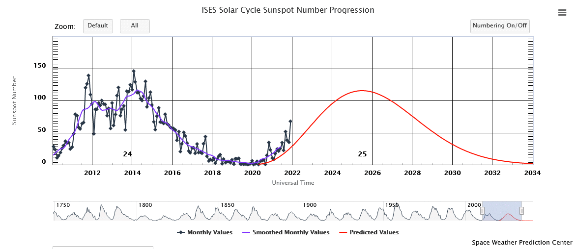
| We hit the rock-bottom of the roughly
11-year-long solar activity cycle at the beginning of 2020. We are now
on the upswing, promising better conditions on the higher HF bands over
the next several years.
The graph below shows sunspot count, which directly affects long-range (beyond the horizon) HF radio transmission here on earth. |
Still more solar activity information
presented in the style of a local TV weather forecast.
The WA8LMF APRS webserver produces multiple map displays.
These displays are generated by 11 copies of UIview running simultaneously on the same computer. They are served by the UI-Webserver component of five of those copies of UI-View32 The VHF, ISS "Satgate", Special Event and 60-meter instances are running in 4 separate VMware virtual machines using micro-Server2003. The HF page is running directly on the Win7-64 host. All instances are connected to APRS Internet servers using filter ports set to receive JUST my own callsigns, the ISS space station object, and the US National Weather Service feed. All stations heard off-the-air in all instances are passed to the APRS Internet System; i.e. all instances function as igates.
The computer's internal sound system is used for EchoLink. All the APRS receive and transmit on the various bands is being handled by three separate Behringer UCA-202 USB external sound cards.
All instances of UIview are set to capture and date-time-stamp an image of their map automatically every 1 minute.
All of this, along with EchoLink, mmSSTV and EasyPal "digital" SSTV is running on an Acer E3-111-P60S 11.8" "netbook" PC dedicated to 24/7 "Ham SuperServer" duty. (Review here)