Road Trip and VARA-vs-Packet APRS Test
October 2024
This road trip, a round-trip between East Lansing, Michigan
and Los Angeles, California was taken between 12 October 2024 and 30 October 2024.
The very indirect touring route was also used to test and compare the
relative performance of conventional 300-baud AX.25 packet and and the VARA
high-performance software modem on HF APRS on 30 meters.
The test setup consisted of a Panasonic CF-53 "Toughbook"
laptop, a Yaesu FT-891 100-watt transceiver, and a Quicksilver Radio "Quick
Stick" 30-meter mono-band hamstick-type mobile whip.
AX.25 packets were generated by a copy of UIview-32 and
the UZ7HO "Soundmodem" soundcard software TNC.
VARA transmissions were generated a second copy of
UIview and the VARA HF software modem. Both modes used the same
Behringer UCA-202 USB
sound card coupled to the same home-brew tone-activated sound card interface
connected to the FT-891's 6-pin mini-DIN "data port". The AX.25
positions used the callsign WA8LMF-2 , while the VARA beacons used WA8LMF-3.
Both instances of UIview (AX.25 packet and VARA) were
also plotting stations-heard on separate maps.
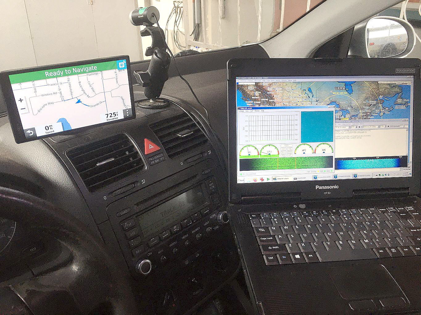
Toughbook installation in my 2006 VW Jetta TDI diesel,
showing VARA, the UZ7HO Soundmodem and three copies of UIview running at the
same time. (The 2M-VHF and AX.25-HF instances of UIview are
behind the VARA instance in the picture.) The Microsoft
720p webcam on the top of the dash is my "Mobile SSTV LiveCAM" used
with "WebCam SSTV Transmit" for live image transmissions from the road.
The total distance driven on the trip was about
6125 miles (9850 Km) -- about 3900 miles (6275 Km) on the more-indirect
outbound leg of the trip; and 2225 miles (3580 Km) on the more direct return
trip.
On the outbound trip, I monitored reception of my home igate
station's beacons on the UIview maps in the car. I also watched the
receive screens of my own gates in Michigan via Internet remote access tools, and checked my own
"last reported position" via APRS.fi & Findu.com on my iPhone in
the car. Multiple other stations
including WA7GMX, WB8SKP, KP3FT and others assisted in monitoring and
igating my transmissions to the APRS Internet (APRS-IS), both on classic
packet and on VARA. I also observed my own home-station beacons from
Michigan directly on 30 meters from the in-car mapping systems.
The results were astounding! On the
outbound trip, there were many days with severe solar disturbances that
severely reduced or blacked-out most HF propagation. Many days, I saw
nothing on my mobile map on AX.25, while multiple stations,
including my own home station, would show on the VARA map.
Monitoring the aprs.fi website showed that the combined
igating efforts of three stations (on the east coast, in the midwest, and on
the west coast provided almost 100% constant reception of my mobile by the
APRS Internet system. I.e. the three stations provided a
continental-scale diversity receiving system for my mobile station.
Out to about 800 miles from home, I was copying my home
station nearly constantly on the VARA mode. By the time I got to the West Coast,
I was still copying it about 16-18 hours a day.
On the return trip, I did a few screen captures of what
I was seeing on the in-car maps.
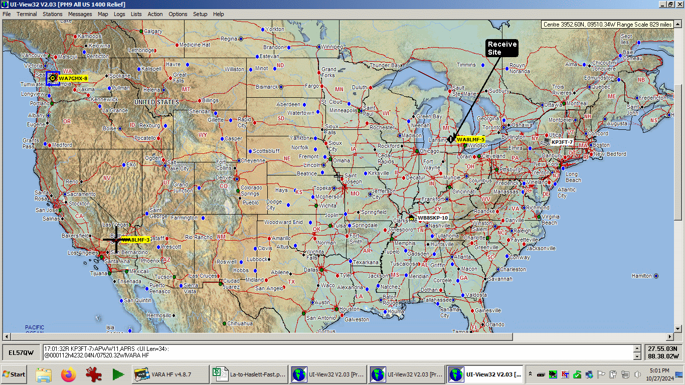
This is a view captured at about 1700 Pacific Daylight
Time while I was stopped on Interstate-15 in Barstow, California (the
cross-hairs location). Note that I was hearing stations from both coasts in
the late afternoon California time. The "Receive Location" called out on
this map refers to my home igate station -- not the location where I
screen-capped the map display. However beacons from the WA8LMF-5 station
(the igate) were actually being heard in the car.
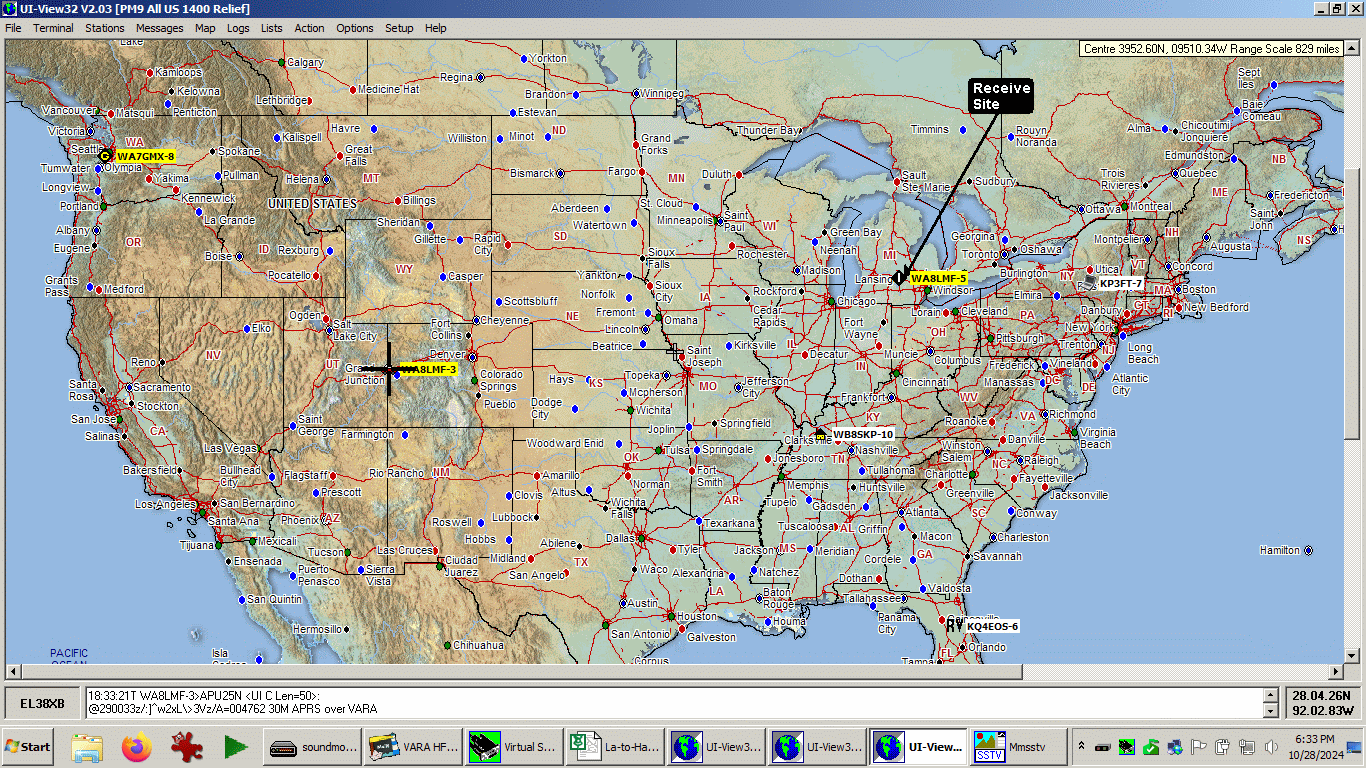
The next day, I captured this view of the VARA screen
from a scenic turnout on Interstate-70 near the
Utah-Colorado state line, at about 1830 local (Mountain Daylight Time).
Again, note how I was hearing both coasts and the mid-west at the same time.
At this time, I was seeing nothing on the AX.25 map!
And yes, I was also running my mobile SSTV "LiveCAM" on 15
meters from a second HF rig at the same time. I was automatically beaconing
live shots of western scenery from the road every 5 minutes as I crossed
Nevada, Utah and Colorado. (Note mmSSTV in the task bar.)
Here are maps captured from Microsoft MapPoint
showing the itinerary of the trip:
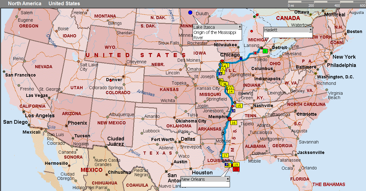
The first half of the outbound trip from central
Michigan to New Orleans, Louisiana:
The second half of the outbound trip from New
Orleans to Los Angeles, California:
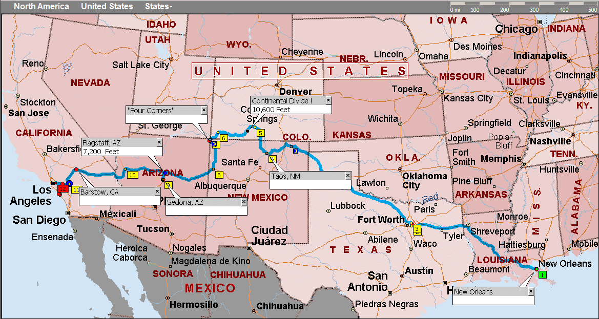
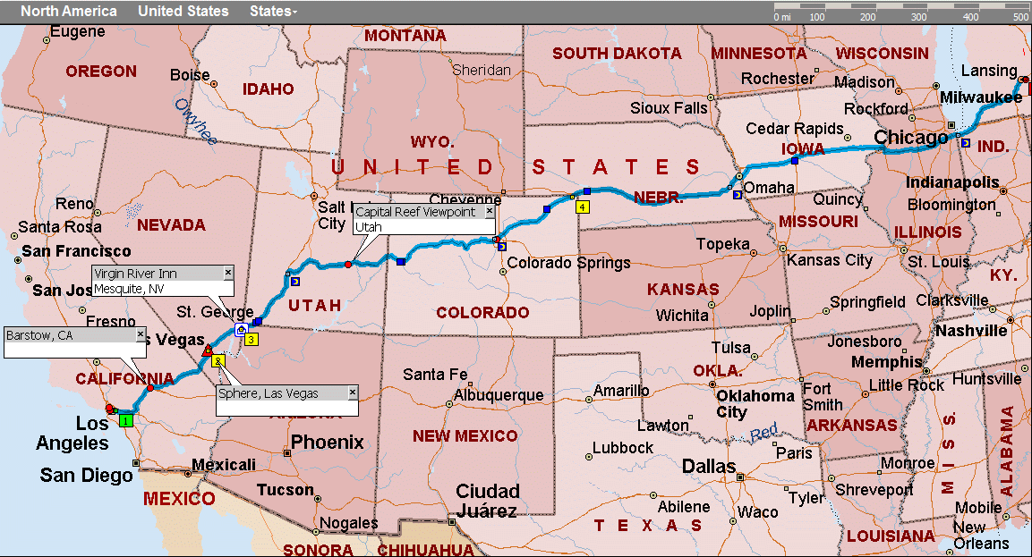
The entire return trip. This is the fastest and most
direct tip between my home QTH in central Michigan and Southern California,
and is the one I normally take.